
MD OF BIGHORN – An out-of-control wildfire near Water Valley in the MD of Bighorn is forcing evacuations in the north Ranchlands area, north of Highway 579 and south of Highway 734.
The MD issued an evacuation order via a Voyent alert just after 8 p.m. Tuesday (July 23).
"There is an out-of-control wildfire approximately 25 kilometres west of Water Valley. All persons in the area closure need to evacuate immediately," the alert states.
"Residents who are in the surrounding area should be prepared to leave their properties with minimal notification when advised."
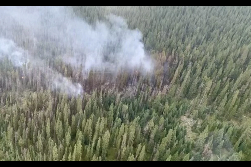
The fire was estimated at 40 hectares around 4 p.m. but has since doubled to 85 hectares as of 8:30 p.m. It is believed to be caused by lightning.
In an update issued just before 10 p.m., provincial fire officials say 13 wildland firefighters, two helicopters and a water truck are currently responding.
"Additional heavy equipment is enroute and anticipated to work through the night building guard," said Anastasia Drummond, a wildfire information officer for Calgary Forest Area (CFA), in an information bulletin. "Multiple airtankers provided support through the evening."
The Studd Creek road is closed between highway 40 and Fallen Timber Road.
A reception centre has been set up at the Water Valley Community Hall and staff are on-site ready to assist evacuees.
Firefighters are on scene, however, the fire is not contained at this time.
Anyone in need of evacuation assistance is asked to contact 403-899-9666. For livestock assistance, call 403-493-4821.
"If you are east of highway 40, west of range road 60, and north of Highway 579 (Harold Creek Road) you must be prepared to evacuate," states the Voyent alert.
To sign up for VoyentAlert and receive further immediate updates and instructions, visit: https://ca.voyent-alert.com/vras/client.html#!/registration.
Extreme fire danger
The wildfire danger across the CFA, which includes the Bow Valley and Kananaskis Country, has climbed to extreme across the region.
Drummond said the heat wave is persisting over Western Canada and is impacting the region.
“The few pockets of moisture we received over the past week are no longer contributing to any relief in the wildfire danger,” she said in an information bulletin.
“Although more seasonal temperatures are expected later in the week, there is little chance of any organized precipitation. Any fires that ignite in these conditions have the potential to grow very quickly and exhibit erratic fire behaviour.”
Since Jan. 1, the CFA has responded to 59 wildfires which have burned just over 97.66 hectares in total.
A fire ban across the entire provincial forest protection area, including the CFA, remains in effect.
“With the steady climb in the wildfire danger, it is more important than ever to follow the terms of the fire ban,” Drummond said.
Since Jan. 1, there have been 957 wildfires recorded in the province’s forest protection area, burning a total of 539,287 hectares.
There are currently 177 active wildfires. Of these wildfires, 59 are classified as out of control, 52 are being held and 65 are under control.
There are currently three carryover wildfires from the 2023 season.
Report wildfires
Under these current conditions, Drummond said it is crucial fire crews can respond as soon as possible to any new wildfire starts.
“The sooner a wildfire is detected, the sooner our wildland firefighters can respond and begin suppression,” she said in the bulletin.
Please report wildfires to 310-FIRE. Thank you to those using the 310-FIRE line to report wildfires.
Road closures
Meanwhile, RCMP are advising area motorists of the following road ways being impacted by wildfires in the area. RCMP wish to advise those departing the area to be aware of extended delays and closures at:
• North boundary: Burnt Timbers Road at the Intersection with Hwy 40, and the Trunk Intersection of 734 & Township Road 302(a) at Range Road 73 (a)
• East boundary: Burnt Timbers Road 303(b) at Range Road 64(a) - GAS PLANT access closed.
• South boundary: Range Road 579 to Dock Mills Rd at Township Road 294 (B)
• West boundary: Highway 40 at Harrold Creek Road 579.
RCMP ask that people avoid these areas during this time for first responders to work and to refer to 511 Alberta for continual road closures and access updates.


